
The Texas Geographic Information Office, along with the Texas Department of Information Resources, established the Data Center Services (DCS) GIS Solution Group to help address the complexities of geographic information systems in the state. The Solution Group provides a platform for sharing information and making unified decisions that will better serve geographic information departments at state agencies. The DCS GIS Solution Group meets monthly.
Data Governance Model
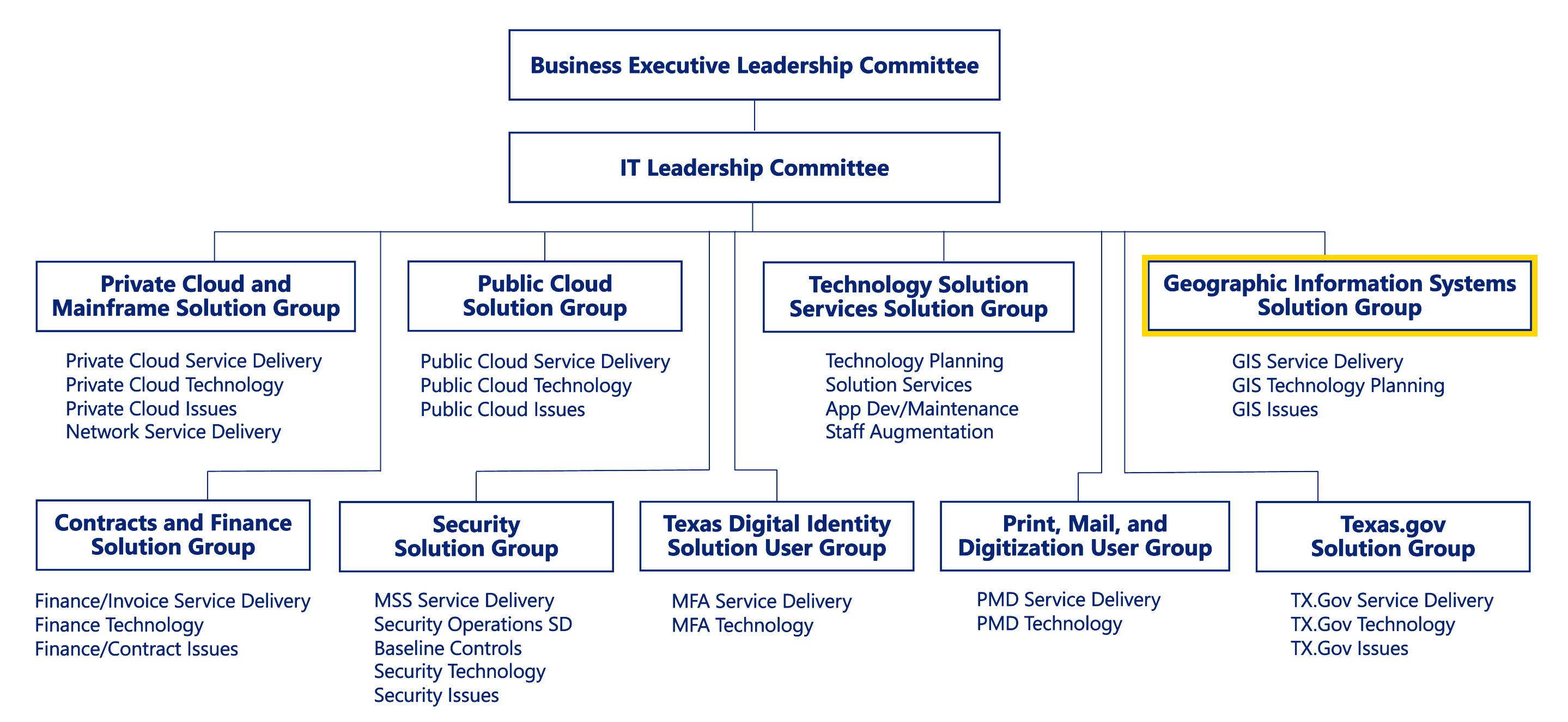
The Data Center Services (DCS) Solution Groups are at the 'front line' to address issues related to specific services provided through the State Data Center. There are five Solution Groups, including the most recently created GIS Solution Group, whose main tasks are to tackle issues and concerns that affect particular services provided by the DCS.
The DCS GIS Solution Group was created to meet the need for a formal team of agencies willing to participate in shared purchases for GIS data and enterprise technology services. The catalyst for creating the DCS GIS Solution Group was a multi-agency joint effort to obtain a state enterprise license to Google’s 6-inch imagery service. In March 2015, a contract between Google and the state of Texas was executed through the DCS to execute a statewide Texas Imagery Service.
Participating Agencies

- Department of Information Resources (DIR)
- Commission on State Emergency Communications (CSEC)
- Texas Commission on Environmental Quality (TCEQ)
- Texas Department of Transportation (TXDOT)
- Texas Water Development Board (TWDB) (via TxGIO).
Ongoing Projects
The DCS GIS Solution Group gathers each month. Topics of discussion include:
Google Imagery Pilot
The DCS GIS Solution Group is tasked with monitoring, managing, and marketing the Google Imagery Service, including imagery update approval and procurement. The following is a list of specific tasks the group is charged to consider and make decisions on. For more information regarding project participation, please visit the Google Imagery Project Page
- Software and application access experience
- Usage metrics and cost model
- Imagery updates to the service
- Prioritization of new imagery purchases
- Progress updates from Google
Geographic Data
The DCS GIS Solution Group discussions include distribution and access to geographic data. Current topics and issues include the following:
-
Authoritative Sources – geographic data produced by trusted and reliable sources that are documented and managed by a credible designated authoritative source (state or local agency).
-
Barriers to Sharing – understanding existing barriers and resolving the challenges of data sharing through collaboration.
-
Statewide Address/Parcel Data – discussions center on the need for a statewide address and/or parcel dataset. The need is present but funding lacks. The DCS GIS Solution Group is addressing the pros and cons of commercially licensed data vs. maintenance of a public domain dataset.
-
Enterprise Data Storage and Access – a work in progress to determine the most cost-effective way to create an enterprise system that would allow storage and access to centrally stored geographic data ready to display in an OGC-compliant geographic information.