Easy Access to Consistent, Quality Imagery Across Texas
Many of us use aerial imagery in our daily lives, whether looking up directions or exploring our neighborhood from above. The State of Texas has collaborated with Hexagon and Sanborn to provide a cost-efficient and widely accessible mapping tool that meets the needs of government agencies - the Texas Imagery Service through the Hexagon Content Program.
The Texas Imagery Service is designed to provide high resolution imagery showing the entire state of Texas with the most recent coverage. The Service provides continuous 6-inch natural color imagery for use in mapping and computer-aided design (CAD) applications, and is available for all state, regional and local governments in Texas, including their contractors.
To get started, visit the Link Request Form using the button below
The goal of the Texas Imagery Service is to serve orthoimagery at full statewide coverage every other year. Currently, the TIS has two statewide flights scheduled for 2022-2025. Please reach out to us via our Contact Form for further details as needed.
The Texas Imagery Service serves statewide 6-inch, natural color imagery for use in mapping and computer-aided design (CAD) applications. It provides state organizations with a current and consistent imagery data source while offering the highest pixel resolution available for any statewide program through an OGC compliant Web Map Tile Service (WMTS) and Web Map Service (WMS).
The Service provides significant cost savings by streaming quality imagery directly to your GIS or map application. There is no need to pay large storage costs associated with imagery files for serving terabytes of data.
The Texas Imagery Service is an annual subscription service paid in full for each year of participation. The service period runs from September 1 to August 31 each year and can be prorated at any time.
Costs for the Service are distributed across state, regional, and local government. State agency cost is based on the amount of data usage in 'levels'. Regional and local agencies pay a flat rate.
State Agencies
Level
Service Requests*
Annual Subscription Fee**
Power
>=20,000,000
$375,000
Advanced
1,250,000 - 19,999,999
$125,000
High
500,000 - 1,249,999
$62,500
Moderate
100,000 - 499,999
$31,250
Minimum
<100,000
$15,625
State Universities
Department - Annual flat fee $15,625**
University Wide - Annual flat fee $125,000**
Regional Agency
Annual flat fee $15,000**
Local Agency
Annual flat fee $6,000**
* State Agency cost is calculated based on an annual metric of service web requests. A web request is every new click, pan, scroll, load or zoom per user in your organization.
** Cost does not include DIR Fee
Yes. For regional and local agencies, your annual rate will be prorated through August 31. For state agencies, your initial annual cost will begin at the lowest level, Minimum, and prorated through August 31.
All subscribers access all the same imagery statewide. Currently, there are no options for smaller areas at a reduced rate.
Yes, per the data use license, private contractors directly supporting work of a subscribing Texas government agency to the Texas Imagery Service may use the service. The subscribing Texas government agency will need to request separate links on your behalf.
The Texas Imagery Service is a subscription service providing licensed imagery data. View the license agreement:
The Texas Imagery Service is a mapping service that is available on-demand and with no data storage costs. It is licensed, hosted, and served by Hexagon. It offers 6-inch resolution imagery, which is four times higher resolution than the 0.5-meter Texas Orthoimagery Program (TOP) imagery and the 0.6-meter National Agriculture Imagery Program (NAIP) imagery.
The imagery represented in the Texas Imagery Service is not in the public domain and is restricted under license.
TxGIO will continue to work in coordination with partners to determine the need for orthoimagery outside of or in addition to the Texas Imagery Service by invoking TOP. This may include imagery acquisition at greater currency than Hexagon’s update cycle goals (targeted for a 3-year refresh cycle of the State) or during different seasonal time periods to accommodate leaf-off conditions. Additionally, at the federal level, we currently expect the statewide 0.6-meter 2 or 3-year NAIP updates, available to the public without restriction, to continue.
Technical Frequently Asked Questions
Click on the button for your GIS software to learn how to add the imagery service.
The Texas Imagery Service is an open-standard service and can be incorporated into a wide variety of GIS/CAD software and web map applications that support open-standard formats such as the Esri suite of products, QGIS, or Global Mapper.
Check with your IT Department or software provider to determine if an OGC compliant web service is supported by your applications.
Yes, per the license, subscribing participants may incorporate the service in public facing web map applications.
A special thanks to the Texas Department of Transportation (TxDOT) for solving this problem. TxDOT reports that since replacing the WMS link with WMTS link, response times have significantly improved.
Download a slideshow tutorial for this process below:
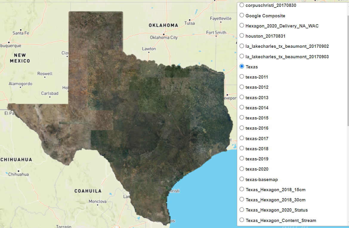
There are several layers in the WMTS and WMS Texas Imagery Service. The ‘Texas’ main layer contains 6-inch imagery from Hexagon flown in 2020. This is the recommended layer for most applications.
Layer Descriptions:
Texas
Recommended Layer: Statewide mosaic of latest available imagery in the Texas Imagery Service. This layer includes consistent, statewide 6-inch imagery flown in 2020 by Hexagon.
texas-basemap
This layer includes roads, county boundaries, major water features, and city names available as base information that were cartographically designed for use on top of imagery while using the service.
Texas_Hexagon_2018_15cm
This layer includes Texas’ major urban areas only flown by Hexagon in 2018 at 6-inch/15cm resolution.
Texas_Hexagon_2018_30cm
This layer includes consistent, statewide imagery flown by Hexagon in 2018 at 1-foot/30cm resolution.
Texas_Hexagon_2020_Status
A repeat of the statewide 6-inch 2020 imagery from Hexagon. Do not use. Use the ‘Texas’ main layer for this imagery.
Texas_Hexagon_Content_Stream
A repeat of the statewide 6-inch 2020 imagery from Hexagon. Do not use. Use the ‘Texas’ main layer for this imagery.
Hexagon_2020_Delivery_NA_WAC
A repeat of the statewide 1-foot 2018 imagery from Hexagon. Do not use.
Google Composite
A statewide 6-inch composite of the latest imagery obtained from Google as a patchwork across the state, years 2014 – 2020.
texas-2011 through texas-2020
These layers contain imagery captured by Google from 2011 – 2020 as a patchwork across the state that were archived after newer imagery became available. These layers each contain any imagery collected within each year.
Hurricane Harvey image layers
corpuschristi_20170830
houston_20170831
la_lakecharles_tx_beaumont_20170902 and 03
These layers include imagery flown over some of the affected areas during the Hurricane Harvey event. They include Corpus Christi flown on 8/30/2017, Houston flown on 8/31/2017, and Lake Charles/Beaumont flown on 9/2/2017 & 9/3/2017.
The official accuracy of the 6 in (15 cm) imagery from Hexagon is +/- 20 in (50 cm). This is very conservative as Hexagon customers have found accuracy to be much higher in most areas.
The aerial imagery from Hexagon were acquired with the market leading Leica ADS100 large format digital airborne sensors. Visit Hexagon’s capture technology page for more information.
To determine the date of the imagery, open your unique preview link. Turn on ‘Texas downloads' and click on the polygons on the map to retrieve the dates.
If your GIS/CAD software can ingest a WMTS, use it over the WMS link throughout your organization. WMTS is optimized for efficient web delivery and map printing.
If your GIS/CAD software cannot ingest a WMTS, use the WMS link.
Both of your unique WMTS and WMS links serve the same imagery to your organization.
Yes, the WMTS and WMS Texas Imagery Service links are OGC (Open Geospatial Consortium) and compatible in ArcGIS Online.
Please use the “Contact and Feedback Form” and we will reactivate or reinstate your links.
Request unique links today if you are working for a public organization in the State of Texas (ie. state, regional or local government) and would like to obtain links for your agency. Visit the trial links form using the button below.
Note: Because the Texas Imagery Service is a restricted license, it is only for use by subscribing public organizations in the State of Texas.
Contractors or any individual working on behalf of a public organization are permitted to use the imagery service if the work being performed directly supports the public organization. The sponsoring agency will need to request service links on behalf of any contractor or outside 3rd party.
To learn about new imagery updates to the Texas Imagery Service, please visit the Latest Updated Imagery map at the top of this page.
Additionally, an email is sent to all subscribing participants when an imagery refresh occurs.
Use the Contact and Feedback Form below. TxGIO will log these issues and work with the AppGeo/Hexagon team to find solutions to correct them in future imagery releases.
The map service tiles are Web Mercator EPSG:3857.
Yes. Subscribing agencies may download the imagery for use within the organization only. For instructions on how to download imagery from the service, use the Contact and Feedback Form below.
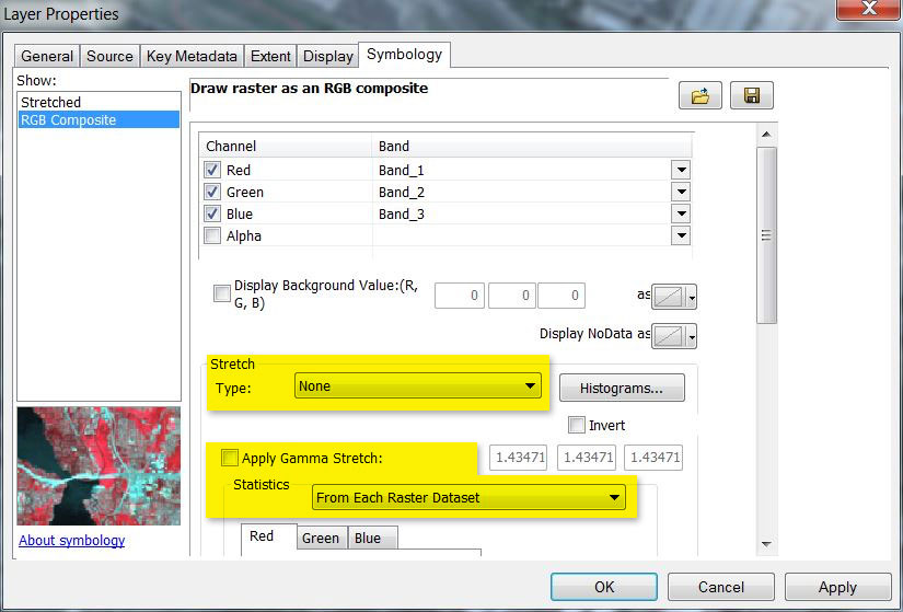
If you are adding the downloaded imagery tiles (not the Service) into ArcGIS, open the Layers Properties dialog and make sure to uncheck the “Apply Gamma Stretch:” option and to set the “Stretch” type to None.
The Layer properties dialog box on ArcGIS
The downloaded JPEG tiles are Web Mercator EPSG:3857.
Use the Contact and Feedback Form below to request a usage report from TxGIO.
If you feel that an unauthorized party has compromised your links, please contact TxGIO immediately. We will disable your current links and re-establish new links for you to use.
Please use the button below to request unique trial links for your organization.